CRJ preview: Enhanced situation awareness for complex disasters
A system combining the use of a Smart UAV, computer-based analysis and 3-D modeling has been developed by researchers in Salzburg to help first responders and incident commanders at complex disasters. CRJ will be looking at the system in detail over the next three issues, but in the meantime, here's a quick preview…
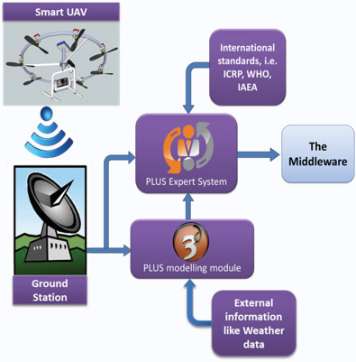
The system, developed by an interdisciplinary team of researchers at the Paris-Lodron University of Salzburg (PLUS, Austria), in close collaboration with first responders, provides advance situational awareness to the incident commanders and first responders to assist them in managing complex disasters. The PLUS ASA System, created as part of the BRIDGE Project, includes the following modules:


Figure 1 (right): The components of the PLUS ASA system
Smart UAV (S-UAV): The ruggedised S-UAV can withstand harsh weather conditions, such as snow, rain and temperatures ranging from -20°C to +40°C). It is equipped with multiple sensors as plug-in modular components, including gas sensors, particle counters, particle mass counter, and sensors for gamma radiation, as well as ambient barometric pressure, relative humidity and air temperature. It is also equipped with a high-resolution video camera and a wide-angle infra-red camera.
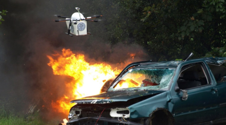
The S-UAV can carry a payload up to five kilos and can fly up to 30 min before its batteries need to be changed. It has a GPS-waypoint function, allowing it to maintain balance in turbulent weather and return to the starting position automatically in case the battery runs out or if the control signal is lost.
Figure 2: The S-UAV delivering live video and other sensor data to the ground station
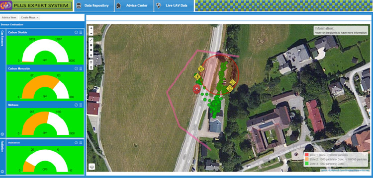
Computer-based Expert System (CES): CES analyses digital information received from the S-UAV and presents advice about recommended response procedures, based on the interpretation of the sensor values detected by the S-UAV. To avoid information overload of the raw data, the CES compares this data to national and international safety standards and recommendations, as defined by key bodies such as the World Health Organization, then assesses the situation, highlights high concentration zones on interactive maps and alerts the incident commander with alarms in the case of excess values. It also advises about Personal Protective Equipment (PPE), response procedures such as safe distances, public safety, hazard information, and first aid for those potentially in need.

Figure 3: CES marks key marks on interactive maps and identifies the level of various hazards
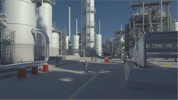
2D-/3D Computer Modelling Module (CMM): CMM creates computer-based 3D models of structures at the incident site and 2D models of a toxic plume in case of an uncontrolled release. This module uses several types of software and draws on the pre-programmed generic models of reality-based structures contained in the EU Critical Infrastructure (CI) Library.

Figure 4: A reality-based model of a chemical facility using 3ds-max
The result emphasises user-friendliness through all phases of emergency response, analysing hazards and uncertainties associated with the incident site, providing a clear picture with pertinent advice about various procedures, and assessing environmental impacts.
With this system the first responders and the incident commander are provided with comprehensive situation awareness. They can spot victims buried under the debris, know what kind of hazards are waiting for them and what PPE can save them from those hazards, estimate the damage done to the buildings; roughly gauge the approximate number of victims and the kind of injuries and symptoms to expect before even entering the region. The possibilities are endless.