A summer of extreme weather
July 2021: Heavy rainfall has triggered devastating flooding causing dozens of casualties in Western Europe, writes the World Meteorological Organization (WMO).
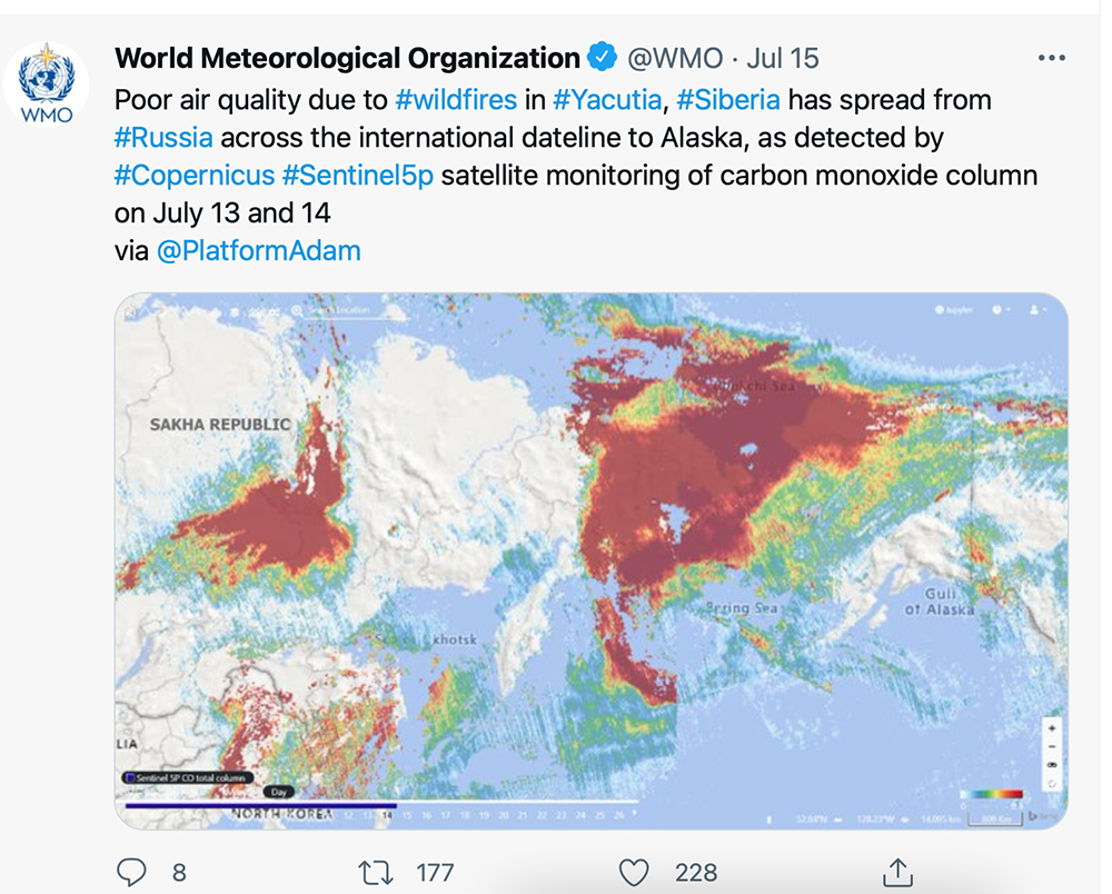
Parts of Scandinavia are enduring a lasting heatwave, and smoke plumes from Siberia have affected air quality across the international dateline in Alaska. The unprecedented heat in Western North America has also triggered devastating wildfires.
"While rapid attribution studies have shown the clear link between human-induced climate change for the unprecedented heatwave episodes recorded in the Western United States and Canada, weather patterns over the whole northern Hemisphere have shown an unusual planetary wavy patterns in this summer. This has brought unprecedented heat, droughts, cold and wet conditions in various places.
"The connection of this large-scale disturbance of summer season with the warming of Arctic and the heat accumulation in the ocean needs to be investigated," said Dr Omar Baddour, head of WMO Climate Monitoring and Policy Division.
European Floods
Some parts of Western Europe received up to two months’ worth of rainfall in two days (July 14 and 15) on soils that were already near saturation. The top one metre of soil was completely saturated or well above field capacity after the intense rain in the most affected regions of Belgium, Netherlands, Luxembourg and Germany.
In terms of the human toll, Germany and Belgium were the worst hit countries by the floods in Europe. Authorities reported more than 100 fatalities, with many more missing as people were trapped or swept away by waters. Images of collapsed houses and landslides showed the force of the waters.
"It is a catastrophe. There are dead, missing and many are still in danger," says Malu Dreyer, President of the German state of Rheinland Pfalz, one of the worst affected areas, with collapsed houses and widespread flash flooding.
According to the German national meteorological service, DWD, about 100 to 150 mm of precipitation occurred in 24 hours between July 14 and 15. The weather station of Rheinbach-Todenfeld (North Rhine-Westphalia) recorded 158 mm, followed by Cologne-Stammheim (North Rhine-Westphalia) with 154 mm, Klein-Altendorf (Rhineland-Palatinate) with 147 mm and Kall- Sistig (North Rhine-Westphalia) with 145 mm.
Throughout the affected countries, national meteorological and hydrological services issued numerous warnings, including top level Red Alerts to warn people of the risk to life.
This situation was down to a near-stationary low-pressure weather system, which established over Germany. This unstable, baroclinic system usually moves slowly over a confined region, and it is associated with strong convergence and upward motion leading to heavy rainfall.
Luxembourg, the Netherlands and Switzerland and parts of north-eastern France were also badly impacted.
In Switzerland, MeteoSwiss described high water levels as 'critical'. The top Level 5 flood warning was in place for lakes Biel, Thun and the Vierwaldstattersee, and level 4 for Lake Brienz, the Rhine near Basel and Lake Zurich.
Flash flooding paralysed London’s transport network on July 12, as around 70 mm of rainfall fell in a short space of time over a highly populated urban area.
Heatwaves
While Central Europe suffered deadly floods, Northern Europe has been gripped by an extended heatwave.
Finland had its warmest June on record, according to FMI. And the heat has extended into July. Kouvola Anjala, which is in southern Finland, has seen 27 consecutive days with temperatures above 25°C. This is the longest heatwave in Finland since at least 1961.
In Lappeenranta Hiekkapakka and Porvoo Kalbådagrund temperature did not drop below 24.2°C (12 h minimum). Both readings tie the warmest night ever recorded in Finland, according to researchers at the Finnish Meteorological Institute.
The Gulf of Finland in the Baltic Sea reached record warmth, up to 26.6°C on July 14, the warmest since records began 20 years ago, according to the Finnish meteorological service.
Western USA and Canada have also been gripped by heat, with many records broken in the most recent heatwave in South-Western USA; Las Vegas tied its all-time record of 117°F (47.2°C), as did Utah.
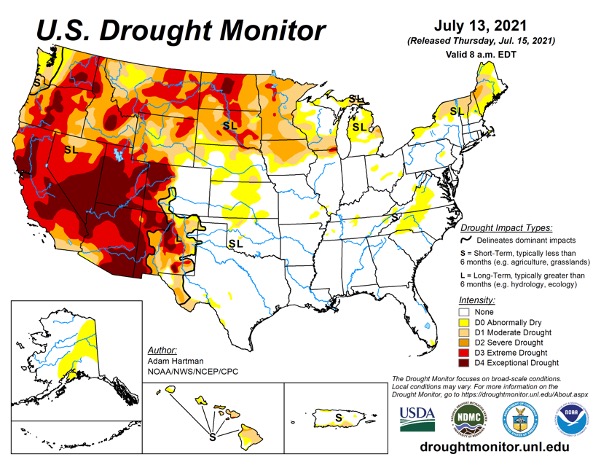
Map courtesy of the National Drought Mitigation Center (NDMC); the US Drought Monitor is jointly produced by the National Drought Mitigation Center at the University of Nebraska-Lincoln, the United States Department of Agriculture, and the National Oceanic and Atmospheric Administration
Death Valley, California reported temperatures of 130°F (54.4°C) on July 9, according to the US National Weather Service in Las Vegas. WMO says it is ready to verify new extreme temperatures: "We are currently evaluating 130°F reading in Aug 2020 at Death Valley, which holds world highest temperature record."
On July 16, the US National Weather Service issued new warnings of excessive heat in Northwest Pacific which was hit by the end of June heatwave.
The megadrought conditions, very dry fuels and heatwaves are fuelling the occurrence of extreme wildfires this year in west USA, as well as western and central Canada.
Climate Change attribution
Climate change is already increasing the frequency of extreme weather events, and many single events have been shown to have been made worse by global warming, says the WMO.
The record-breaking heatwave in parts of the US and Canada at the end of June would have been virtually impossible without the influence of human-caused climate change, according to a rapid attribution analysis by an international team of leading climate scientists. Climate change, caused by greenhouse gas emissions, made the heatwave at least 150 times more likely to happen.
As the atmosphere gets warmer it holds more moisture which means it will rain more during storms, increasing the risk of floods.
Coinciding with the heavy rainfall in London, the UK’s Met Office issued a new study which examines how high-impact weather in the UK, such as extremely hot days, heavy rainfall and very cold conditions, could be affected at different levels of global warming.
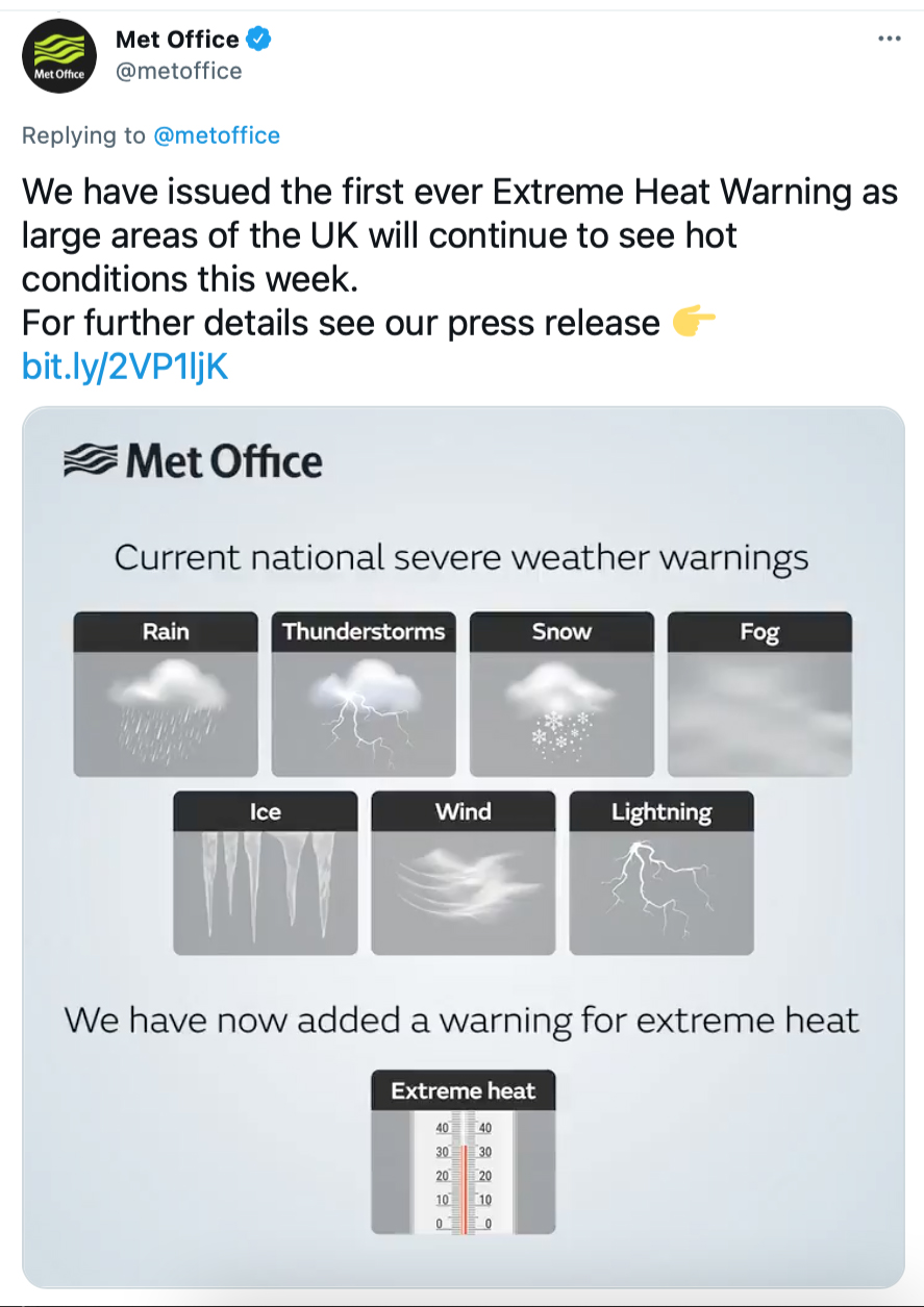
The UK's Met Office issued its first ever warning for extreme heat in July 2021
The study, published in the journal Climatic Change, found that the higher the level of global warming, the projected increase in frequency or severity or both will be stronger for hot weather, droughts and flooding in the UK. These high-impact weather events can cause significant disruption across the UK affecting sectors such as health, transport, agriculture and energy.
The number of days of high-impact heavy rainfall in the UK leading to severe weather warnings could rise by three days per year. Currently, there are around seven days per year (range six to nine days) in England and Wales with intense and prolonged rainfall that could lead to river flooding. With a 4.0°C rise in global temperature, this could rise to 11 days per year (range 10-13 days).
Under a 2.0°C rise in global temperature it is expected England and Wales will receive nine days (range eight to ten days) of intense and prolonged rainfall.
IPCC Special Report Global Warming of 1.5°C mentions that human-induced global warming has already caused multiple observed changes in the climate system. Trends in intensity and frequency of some climate and weather extremes have been detected over time spans during which about 0.5°C of global warming occurred. Changes include increases in both land and ocean temperatures, as well as more frequent heatwaves in most land regions. Further, there is substantial evidence that human-induced global warming has led to an increase in the frequency, intensity and/or amount of heavy precipitation events at the global scale.
Several regional changes in climate are assessed to occur even with global warming up to 1.5°C, as compared to pre-industrial levels, including warming of extreme temperatures in many regions, increases in frequency, intensity and/or amount of heavy precipitation in several regions.
This news item is republished with permission of the WMO